inquiry
Leave Your Message
0%

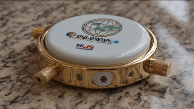
Nowadays, the need for precision in geospatial surveying is really ramping up, and guess what? Mini Rtk Gps technology is shaking things up big time in this field. A recent market report has some interesting news: the global GNSS/GPS market is set to boom, thanks to tech advancements and the growing demand for accurate data across various sectors like agriculture, construction, and even self-driving cars! At the heart of this innovation is Shanghai Apekstool, or APEKS for short, which started its journey in Shanghai, China. They’re really leading the charge, offering top-notch geospatial surveying products and solutions. By focusing on GNSS/GPS systems, APEKS is dedicated to delivering quality and performance that adapt to the ever-changing needs of professionals out there. So, as we dive into finding innovative solutions with the best mini RTK GPS tech, we're all set to change the game in terms of accuracy and efficiency in surveying practices around the globe.

Innovative Solutions for Achieving Precision with Best Mini RTK GPS Technology

Exploring the Evolution of Mini RTK GPS Technology in Precision Mapping

You know, the way Mini RTK GPS technology has come along really blows my mind. It’s totally changed the game for precision mapping, making it a lot easier and quicker for industries like agriculture, construction, and even environmental monitoring to get things done. Back in the day, using RTK (Real-Time Kinematic) networks meant you had to deal with a ton of infrastructure and resources. So, naturally, it was mostly the big projects that got all the attention. But now? Thanks to some really cool advancements in miniaturization and signal processing, we’ve got Portable Rtk solutions that still nail high accuracy. According to a report I came across by Markets and Markets, they think the RTK GPS market will jump from about 3.1 billion bucks in 2020 to nearly 6 billion by 2025. Talk about a leap! This is mainly because everyone’s craving that high-precision data more than ever.

What’s really exciting is how these little devices are stepping up in real-time data collection. Seriously, they can hit centimeter-level accuracy, which means folks can now pull off detailed topographic surveys and mapping tasks that used to need all sorts of fancy (and expensive) gear. Oh, and get this—there’s a study from the International Journal of Remote Sensing that found when you combine Mini RTK systems with drones, the mapping accuracy shoots up, slashing errors by as much as 20% compared to the old-school methods. This whole shift is not just about making things easier; it's also changing the way decisions are made, enhancing our ability to come up with smarter, data-driven strategies across various fields. Isn’t that pretty neat?

Innovative Solutions for Achieving Precision with Best Mini RTK GPS Technology

Key Features of Best Mini RTK GPS Devices for Accurate Measurements

You know, mini RTK GPS tech has really changed the game when it comes to precision measurement in so many industries – think agriculture, construction, and more. One of the standout features of these mini RTK GPS devices is their crazy accurate centimeter-level precision. This kind of accuracy is a must-have for stuff like land surveying and keeping track of crops. According to a report from Geospatial World, the demand for these precise positioning systems is expected to skyrocket, with a growth rate projected at 15% a year over the next five years, which just goes to show how much folks are leaning on mini RTK GPS for super accurate measurements.

Another cool aspect is how these devices are hooking up with advanced communication protocols like NTRIP (that’s Networked Transport of RTCM via Internet Protocol, in case you were wondering). This allows users to easily tap into a dependable source of correction data. Plus, they come with solid connectivity options like Bluetooth and Wi-Fi, which gives users the freedom to access real-time data right in the field. And get this – a recent study by Markets and Markets points out that the miniaturization of GPS tech has led to devices that are not only portable but also super energy-efficient. This means they can run longer without needing a recharge, which is fantastic news for pros who rely on real-time data to make quick decisions.

Innovative Solutions for Achieving Precision with Best Mini RTK GPS Technology

Feature Description Accuracy RTK Range Battery Life
Real-Time Kinematic (RTK) A satellite navigation technique that enhances location accuracy. ±2.5 cm 10 km 12 hours
Multi-constellation Support Utilizes multiple satellite systems for improved accuracy. ±1.5 cm 15 km 14 hours
Compact Design Lightweight and portable for easy transport and use. ±3 cm 8 km 10 hours
User-friendly Interface Intuitive controls and display for easy operation. ±2 cm 12 km 11 hours
Durability Built to withstand tough environmental conditions. ±3 cm 5 km 9 hours

Real-world Applications: How Mini RTK GPS is Transforming Various Industries

You know, mini RTK GPS technology is shaking things up in a bunch of industries with its amazing precision and efficiency. Take agriculture, for instance. Farmers are really getting on board with mini RTK GPS systems to level up their field mapping and crop management game. This tech lets them gather data in real-time, which means they can plant, fertilize, and harvest with incredible accuracy. It’s pretty cool because by using these advanced tools, they’re cutting down on waste and boosting yields, which makes their operations more sustainable and, let’s face it, more profitable too!

And it’s not just agriculture; in construction, mini RTK GPS is really changing the way things get done. Surveyors are using this technology to nail layouts and measurements with pinpoint accuracy, making sure everything aligns just right with the blueprints. That way, they dodge those annoying and costly mistakes that can throw a project off track, leading to a smoother ride when it comes to execution.

Innovative Solutions for Achieving Precision with Best Mini RTK GPS Technology
Pro tip: If you’re in the market for a mini RTK GPS system, don't forget to check if it’s compatible with what you already have and think about what your industry really needs.

Another cool use is in urban planning. Here, mini RTK GPS plays a big role in mapping out infrastructure projects. Planners can tap into its high accuracy to do site assessments, which helps ensure that new developments fit in nicely without making a mess of what's already there.

Tip: Keep that mini RTK GPS software and hardware updated regularly if you want to keep up with accuracy and efficiency in your workflow. It really makes a difference!

Comparative Analysis: Top Mini RTK GPS Solutions on the Market Today

You know, the rise of mini RTK GPS tech has really shaken things up in the geospatial surveying world. It's pretty amazing how much better precision and reliability we’re getting all packed into smaller devices. I came across this industry report saying that the global RTK GPS market is set to grow by about 15.8% every year until 2028! That’s largely due to the booming demand for precision in agriculture, construction, and environmental monitoring. It really highlights how important it is to come up with innovative solutions that deliver accurate positioning while still being affordable and easy to use.

Now, if you’re looking at the mini RTK GPS options out there, you’ll see that things like accuracy, versatility, and how smoothly they integrate into existing systems are super important. Companies like Shanghai Apekstool (or APEKS for short) are really leading the pack, offering top-notch GNSS/GPS systems geared towards a variety of applications. They’re all about providing high-quality tools for surveying, which really helps professionals make the most of mini RTK GPS technology. The cool part? Many of these systems can hit centimeter-level accuracy! That’s crucial, especially in fast-paced project environments where getting it right is a must.

Future Trends: What’s Next for Mini RTK GPS Technology in Precision Navigation

You know, mini RTK GPS technology is really shaking things up in precision navigation, especially for farmers. More and more, they're turning to autonomous systems for stuff like planting and harvesting, and man, the need for super accurate positioning tools has skyrocketed. These mini RTK GPS systems can pinpoint locations with centimeter-level accuracy, which lets agricultural robots and drones work more efficiently than ever before. It’s awesome because not only does it boost productivity, but it also helps reduce resource waste—really important as farmers deal with rising costs and sustainability issues these days.

Looking ahead, it seems like advancements in mini RTK GPS tech are only going to push the boundaries even further. We’re talking about a market that’s expected to grow as autonomous tractors and agricultural robots become the norm. Plus, things like better signal reliability and teaming up with AI are just around the corner. This is exactly what’s going to gear up the next wave of developments, making these machines way better at adjusting to different field conditions on the fly. So as we step into this more automated and data-driven way of farming, mini RTK GPS is definitely going to be a key player in shaping the future of agriculture and precision farming.

Unlocking Precision: Exploring the AP50 Vision IMU-RTK GNSS Receiver's Advanced Technology Integration

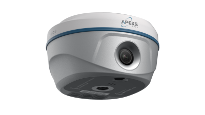
The AP50 Vision IMU-RTK GNSS Receiver stands at the forefront of advanced technology with its innovative integration of Apeks' photogrammetry capabilities. This remarkable device enables users to capture accurate 3D coordinates rapidly through the use of its front camera. By simply shooting a video or taking a series of photos, professionals can gather data for hundreds of points in just minutes—transforming the way surveying is conducted in challenging environments.

What sets the AP50 Vision apart is its ability to operate effectively in hard-to-reach and signal-obstructed locations. Imagine surveying areas under overpasses, eaves, or near power poles, where traditional methods face significant challenges. With the AP50 Vision, users can navigate these hazardous points safely and effortlessly, turning the arduous task of surveying into a streamlined process. The interplay of IMU (Inertial Measurement Unit) and RTK (Real-Time Kinematic) technology further enhances the receiver’s precision and efficiency, allowing for real-time corrections that increase data accuracy.

Through its user-friendly interface and advanced measurement techniques, the AP50 Vision IMU-RTK GNSS Receiver is revolutionizing the way surveyors approach complex terrains. The ability to capture high-resolution data quickly not only saves time but also ensures reliability. This innovative solution embodies a leap forward in surveying technology, making it an essential tool for professionals who demand precision and efficiency in the field.

FAQS

: What industries are benefiting from mini RTK GPS technology?

: Mini RTK GPS technology is benefiting various industries, including agriculture, construction, and urban planning, by providing unparalleled precision and efficiency.

How is mini RTK GPS used in agriculture?

In agriculture, mini RTK GPS systems are used for optimizing field mapping and crop management, allowing for precise planting, fertilization, and harvesting while enabling real-time data collection.

What advantages does mini RTK GPS provide to farmers?

Mini RTK GPS helps farmers reduce waste, improve yield, and make agriculture more sustainable and profitable through precise navigation and data.

How does mini RTK GPS enhance construction projects?

In construction, mini RTK GPS enhances project accuracy by enabling surveyors to perform layouts and measurements with exceptional precision, minimizing costly errors and delays.

What should I consider when selecting a mini RTK GPS system?

When selecting a mini RTK GPS system, consider its compatibility with existing equipment and the specific requirements of your industry.

What role does mini RTK GPS play in urban planning?

In urban planning, mini RTK GPS assists in mapping out infrastructure projects and conducting site assessments with high accuracy, ensuring developments do not disrupt existing environments.

How is the demand for mini RTK GPS technology evolving?

The demand for mini RTK GPS technology is rapidly increasing, particularly in agriculture, as farmers rely more on autonomous systems for planting and harvesting.

What future advancements can we expect for mini RTK GPS technology?

Future advancements may include improved signal reliability, integration with AI, and enhanced operational capabilities for autonomous tractors and agricultural robots, driving the next wave of development.

Why is regular software and hardware updating important for mini RTK GPS systems?

Regularly updating mini RTK GPS software and hardware is essential to maintain accuracy and efficiency in operations across various applications.

How does mini RTK GPS impact resource management in agriculture?

Mini RTK GPS minimizes resource waste in agriculture by enabling more efficient operations of agricultural robots and drones, addressing sustainability challenges in the sector.

Elena

Elena

Elena is a dedicated marketing professional at Shanghai Apekstool (APEKS), a leading provider of innovative geospatial surveying and mapping products. With a deep expertise in GNSS/GPS systems, total stations, levels, and theodolites, she plays a crucial role in communicating the core benefits and......
Previous Top 10 RTK Col Antenna Manufacturers from China at the 137th Canton Fair